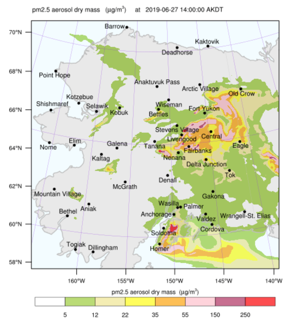
It is fire season in Alaska and a very smoky Thursday in the Fairbanks area.
The vegetation in the Alaskan Interior (roughly the area between two mountain ranges, the Brooks Range in the north and the Alaska Range in the South) mostly consists of boreal forest – black and white spruce, larch, birch and quaking aspen – with easily burnable undergrowth and a thick organic soil layer in the coniferous parts. This type of forest has long been adapted to a cycle driven into a new round by wildfire. But with climate change, the fire intervals – the time between successive burns, usually over 100 years – have become shorter and areas burned have crept upwards.
Right now, there are many relatively small fires surrounding Fairbanks that are responsible for the smoke. But they are only kept relatively small by the excellent work of our wildfire management services (a complex effort involving both federal and Alaska state agencies, called Alaska Interagency Coordination Center, or AICC). And one of the fires to the north-west of Fairbanks, the Shovel Creek fire, now exceeds 1000 acres (400 ha), is very active, and has put several residential neighborhoods under an evacuation warning. My partner and I live on the east side of town, and the situation there looks about like this now:
Mapping services and data sources available to the general public have become much more widespread, and that’s great. And private citizens, fire management agencies and researchers publish a wealth of photos. But with the flood information comes a challenge: to learn how to interpret it. Because if we don’t, more information can mean more anxiety. Let’s see how we do for the fires in the area where I live.
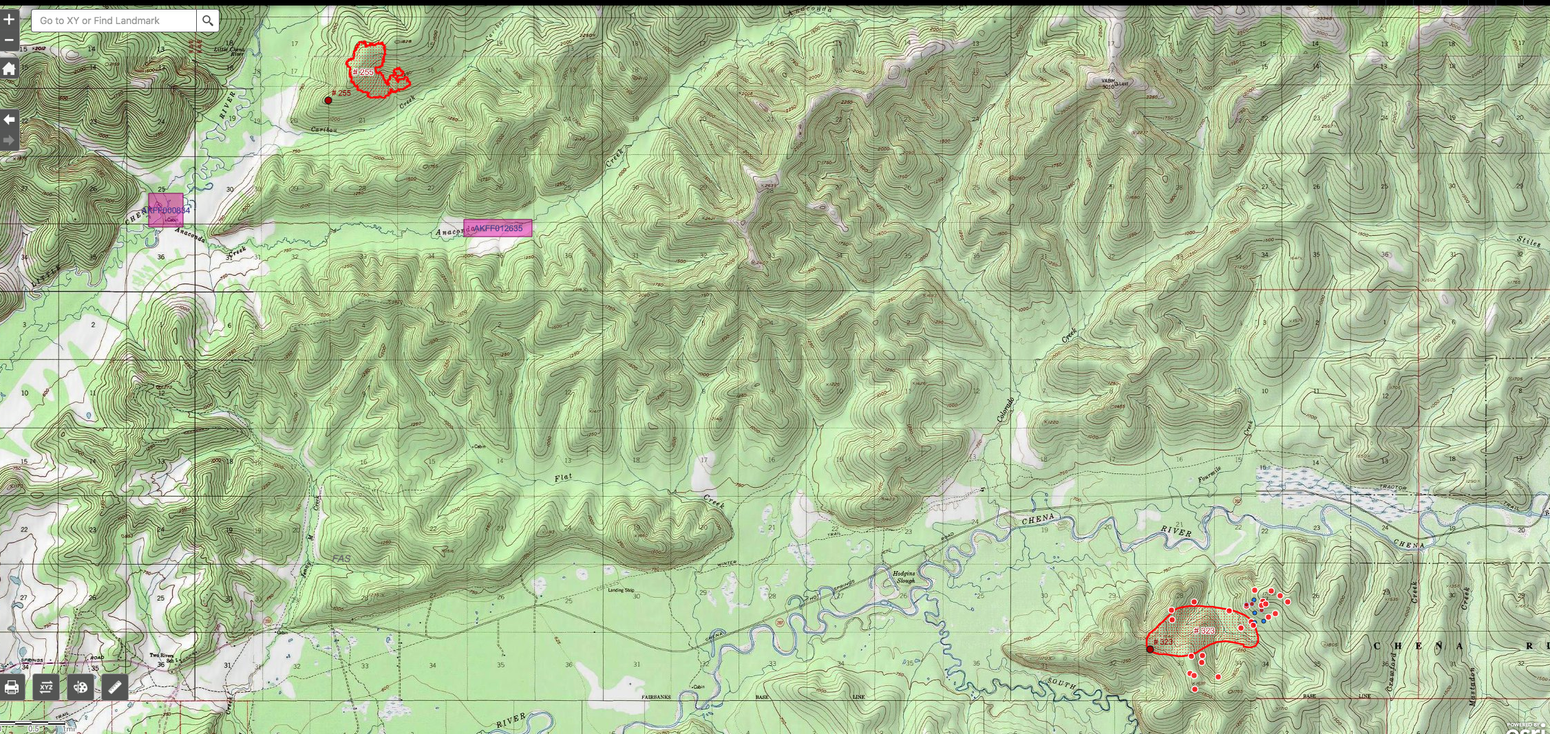
Last week, we were mostly worried about the Caribou Creek fire (north edge of the map), which is about 7 miles (11 km) due north of our current home. (My spouse and I are in the process of buying and hopefully soon moving to another home very close by, and the fires are clearly making it harder to get the insurance providers to issue the policies we need!) That fire was immediately strongly attacked, and was already in the process of being controlled after received a good dousing with rain last weekend.
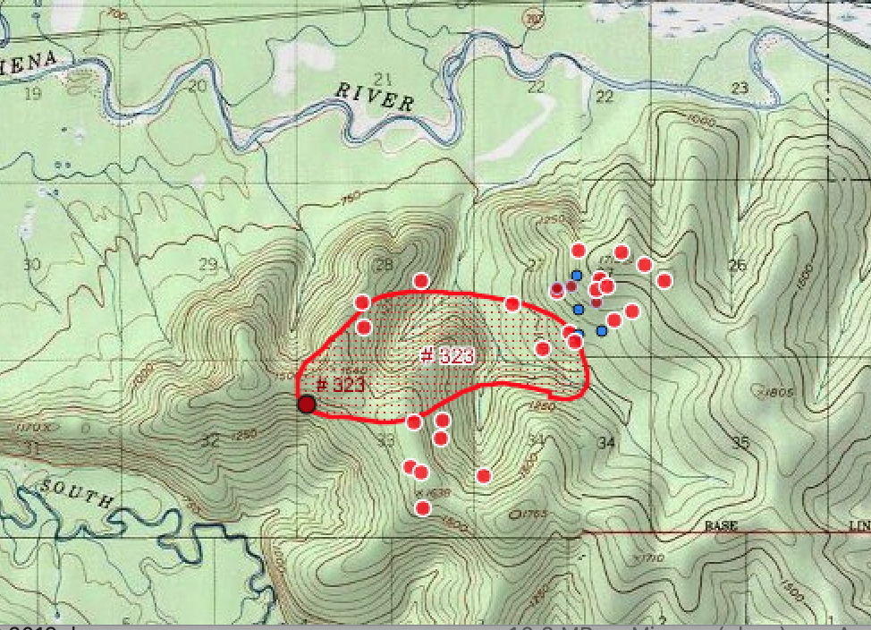
As you can see in the map, there is a fire perimeter as well as one red, black-edged dot that indicates the latitude and longitude where the fire was originally thought to have started. But that’s all. However, for the fire east of us (Nugget Creek fire — many fires here are named after the nearest creek, river or sometimes mountain or street), you can also see white-rimmed red dots as well as blue and darker red dots. These are fire detections from satellite observations, and they are more recent than the fire perimeter drawn by the fire services. So by looking where those dots are relative to the known fire perimeter, you can get an impression where the fire is moving. In this case, mostly east and south, plus a little bit north. (The fire is boxed in by rivers west and further north, luckily.) The reason this fire is more active than Caribou Creek is that it is in an uninhabited area (a state recreation park used by hikers etc.) and was NOT initially fought with vigor. And that’s a good thing in principle: it is normal for this forest to burn occasionally. If we never allow it, dead debris is just going to accumulate, and future fires might be that much worse. However, once the nuisance from the fire becomes too great, or the fire approaches areas where it could do damage, the fire agencies will decide to fight it – which is exactly what happened.
Here are some pictures of the Nugget Creek fire from yesterday that illustrate why concern has risen:
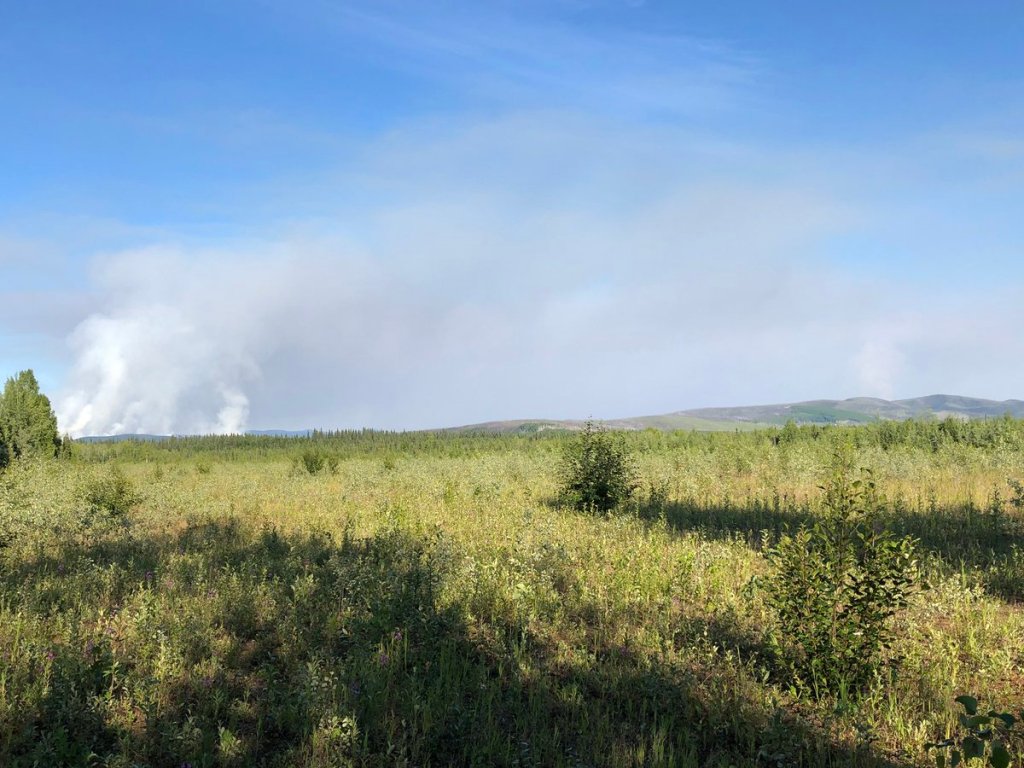
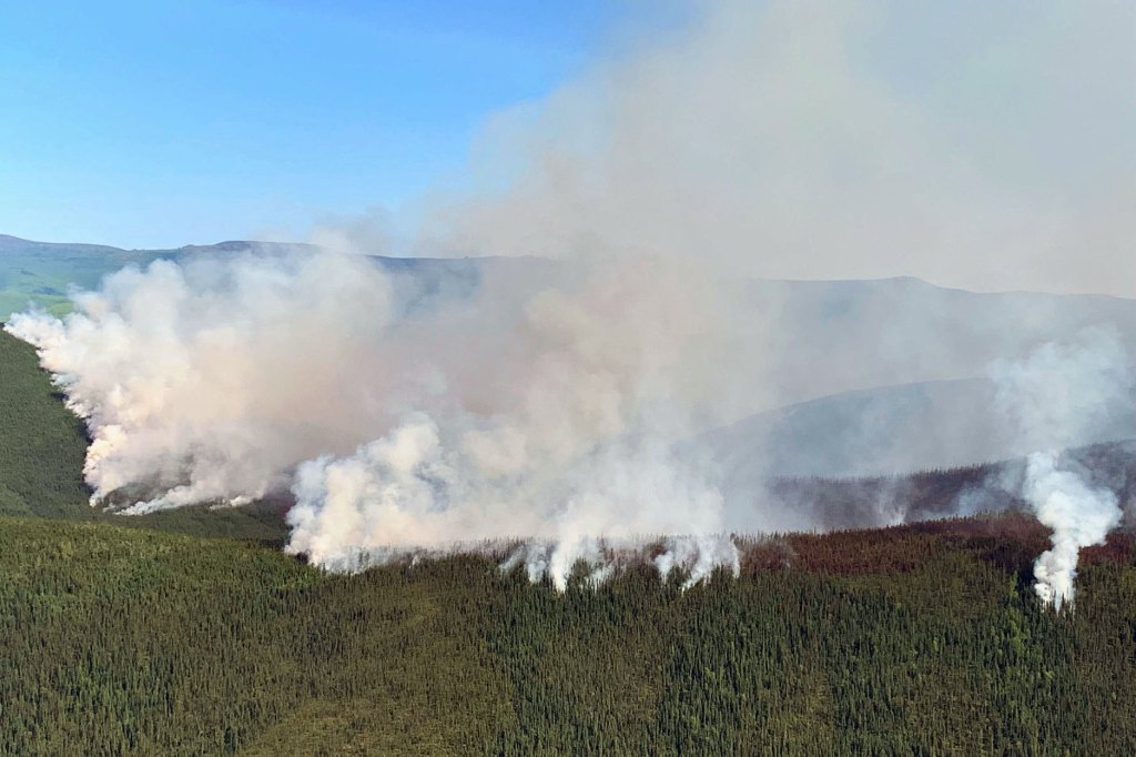
The second photo in particular shows that the fire is active along its perimeter, with the smoke being driven backwards, into the already-burned zone (“fire scar”). This is called “backing”.
Backing is one of the terms for fire behavior that it is useful to know. Even more useful, here in the boreal forest of North America, are “torching” and “spotting”, both considered extreme behaviors Torching is a behavior that happens at high intensities in our spruce forests: individual trees, often one after the next, light up in combustion like a torch, with flames rising high and usually a very large amount of smoke. Spotting is another extreme behavior. It means that the fire is driven forward by wind, jumping ahead of the existing fire front by new ignition from falling embers. The fire in the last picture is a highly active fire, but as of the picture neither torching nor spotting. Especially for spotting, you’d have to have wind that blows in the other direction, driving embers ahead of the front.
Why am I harping on words like “spotting”? Because I’ve been seeing a misconception on social media, created by the excellent new fire maps! Let’s zoom in on the map:
Those dots that signify the locations of new satellite-based fire detections? I’ve seen people on social media call this situation “spotting”. But it is not. In fact, when I make fire maps, I prefer depicting the detection as whole footprints, rectangles (or nearly) that indicate what a satellite image pixel looks on the ground. Because the satellite images we use for this are not high resolution: each dot actually covers an area of about (at least) a quarter mile by a quarter mile.
The hobby linguist in me wonders if, given that the public is now used to these near real-time fire detections being available as dots on a map, maybe the term “spotting” will be more and more used in this way. Because it is relevant whether there are new fire detections or not (though to be honest, that’s a lot more complicated than it looks like at fist). “OMG, there are spots of new fire out to the east… the fire is spotting!” To be sure, if the fire is spotting via flying embers, then it is likely that new detections will show up as dots on the next available map. But I do need to point out that spotting, the extreme fire behavior is not the same as new spots on a map. Rather, any movement of the fire, even medium-intensity propagation of the combustion with no spotting at all, will appear as new dots. “Spotting” means a particular way of a high-intensity fire moving ahead, and new fire detections on a map are just new fire detections on a map.
Sources of fire information for Alaska:
- AK Fire Info. Blog-style, up to date, excellent information about what’s going on, which fires receive what type of attention, planned community meetings, pictures and more.
- Official BLM/AICC map site. Tip: Use the icons to select the background you like. I prefer “US Topo Map” or “Imagery with labels”.
- “Old” BLM/AICC map site – harder to navigate, but has also some information the new one hasn’t.
- UAF Smoke forecasts, run daily based on satellite fire detections and AICC data. Also has a simple “current fires” map.
- NOAA smoke forecasts for Alaska. May be interesting for people in the Yukon Territory in Canada. Click on the check mark between “near surface smoke” and “loop”.
