After an incredibly warm (and low-snow) start of winter in 2018, temperatures plunged to proper sub-Arctic winter values. A few days ago, we were worrying about thawing (with temperatures in the 30s °F / around 0 °C), and then down the curve went. Last night we reached -40 (choose your unit: the scales meet at -40) as per our consumer-grade Davis weather station. That’s the official definition of “cold snap”, and it’s the first of the season.
The Fairbanks area is well known for its extreme atmospheric temperature inversion patterns. And on map provided by the commercial service Wunderground it is very apparent today (click on the image for a bigger version with readable temperature labels):
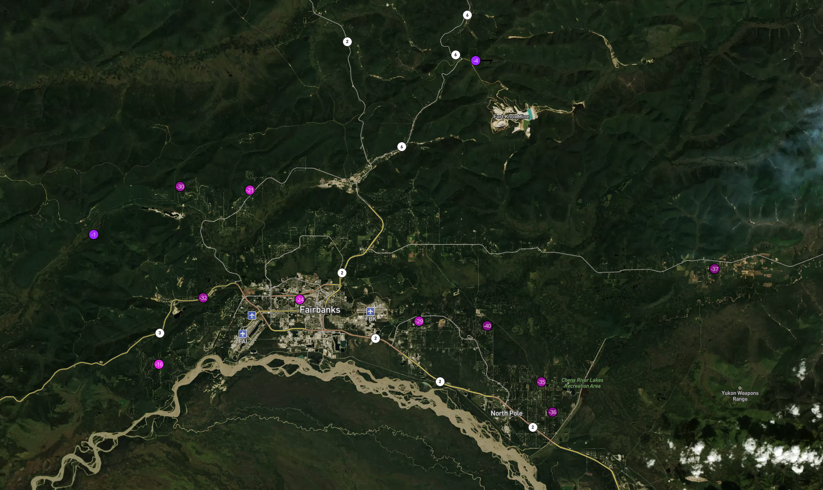
Higher elevations, such as Cleary Summit, a mountain pass on the Steese Highway north of Fairbanks, are currently about 30 °F/17 °C warmer than the valley bottoms. Where we happen to live (and which is why “a house in the hills” is something we keep looking out for).
Life as -40 slows down. You can go out just fine, and you’ll be amazed by how well sled dogs are adapted to this extremely harsh weather, but it’s not really fun to exercise outside, plastic is brittle, batteries go flat … and you don’t have time for recreation because you need to keep an eye on the house systems. Especially to make sure that water stays liquid, be it in drains or incoming pipes.
The house we live in is made from three-sided logs, which retain heat quite well. We mostly heat with a very efficient and Toyo oil stove. But we have a wood stove to fall back on, in case the electricity or the Toyo have an outage. We decided to fire it up today, to make sure it works well and because it creates a nicer warmth in the corners too far from the Toyo. Wood burning is a huge and complicated political hot potato in interior Alaska, and a topic too complicated to go into in this post. The short version is: it’s traditional, economical and doesn’t require electricity; but it also contributes to air pollution in a way to occasionally render the winter air in Fairbanks one of the worst in the planet, so at a minimum eliminating the most polluting types of burners is quite imperative for the health of the population.
Our stove is an EPA-certified Blaze King with a catalytic converter, but even so: however pleasant wood heat is, you’ll get an impact on the air you breathe. Air quality indices only talk about outdoors air (and usually averaged over 24h). Another topic, though, is indoors air. I took the opportunity to pull out a little PM2.5 sensor that I bought online a while ago. (Disclaimer: I haven’t checked the calibration. At least during the summer wildfires it seemed to work reasonably well and deliver believable values.) Today, before starting the wood stove and with a blazing oil stove, it measured around 15 µg/m3, which is an ok value. With the wood stove, it was at 66 µg/m3 after an hour, went up to just above 100 µg/m3 and then settled in the 80s, which you will find labeled as “unhealthy for vulnerable populations”. My setup is here, with the sensor in the left foreground. It talks to the computer via a USB-to-serial interface. (I wrote the app to teach myself Dash for interactive real-time applications.)

This, of course, is measured indoors, not outdoors, and in the 24h average we will quite likely end up in the “moderate” range for the day. We’re fine.
On a related note, no one should retain too rosy a picture of the air pre-historic and pre-industrial populations used to breathe. Notwithstanding, of course, their insights about the relationship to nature: if a culture or people practices indoors wood or coal burning for cooking and warmth, chances are that respiratory illnesses were prevalent.
Addendum: Approximately 5-6 h after we first started the wood stove, the picture has changed a little bit. PM2.5 values came progressively down to 15-25 µg/m3, pretty much to where they were before we started. Clearly, the first fire-up phase is what generates the most pollution, while collected crud from inside and outside the stove burned off. In contrast, low-to-medium hot, steady operation deteriorates the air much less. Also, I believe it takes a few hours for the catalytic converter to reach its operating temperature. Apparently, letting the stove cool down completely and sit cold for extended periods is a recipe for air pollution. The lesson from this is: If you want to heat with firewood, make sure you have a device with a certified catalytic converter, use it continuously and burn dry, well-seasoned wood.
